A circumnavigation of the western English Channel
Table of Contents
- Foreword
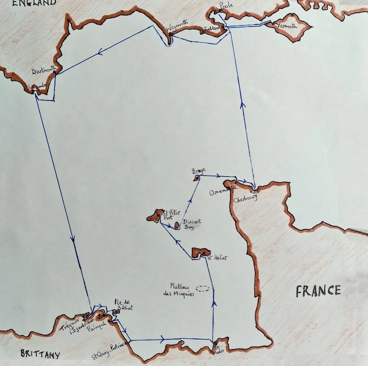
- The Route
- Yarmouth
- Yarmouth - Studland - Poole
- Poole
- Poole - Weymouth
- Weymouth
- Weymouth - Dartmouth
- Dartmouth
- Dartmouth - Salcombe
- Salcombe
- Salcombe - Tréguier
- Tréguier
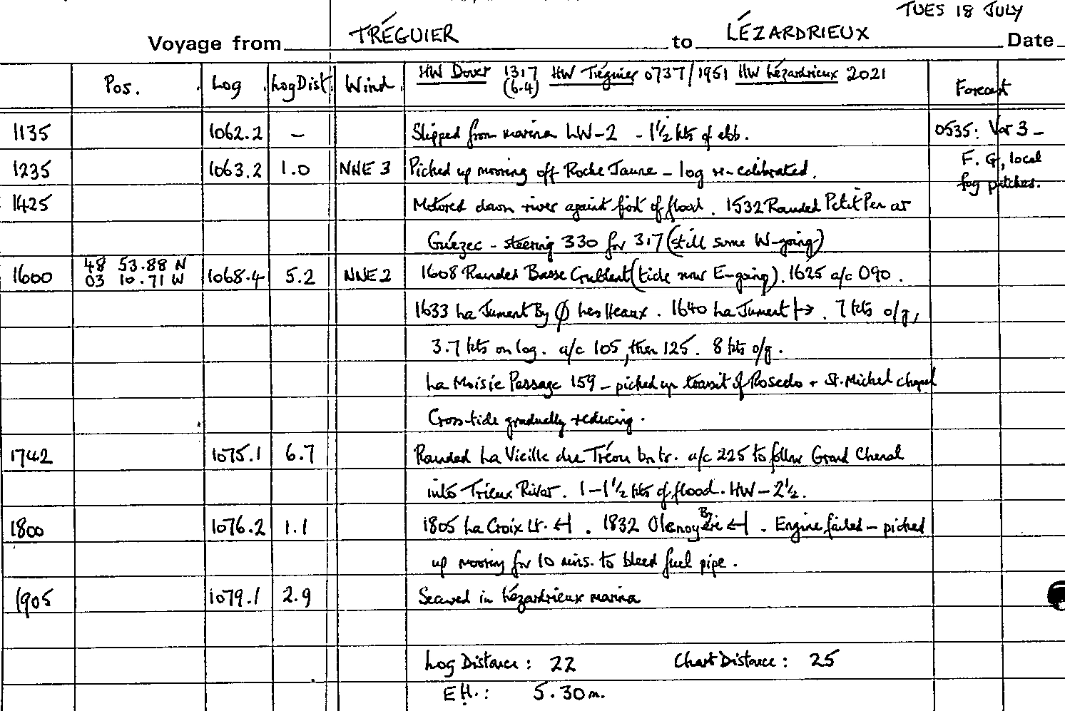
- Tréguier - Lézardrieux
- Lézardrieux - Île de Bréhat
- Île de Bréhat - Paimpol
- Paimpol
- Paimpol - St Quay
- St Quay
- St Quay - St Malo
- St Malo
- St Malo - St Helier
- St Helier
- St Helier - St Peter Port
- St Peter Port - Sark
- Sark
- Sark - Alderney
- Alderney
- Alderney - Omonville-la-Rogue
- Omonville-la-Rogue
- Omonville-la-Rogue - Cherbourg
- Cherbourg - Studland Bay
- Studland Bay - Yarmouth
- Conclusion
Foreword
After Hannah finished her PhD and while we waited for our US visas to come through, my father, Hannah and I spent the summer of 2000 sailing my parents' 28-foot Twister, 'Macaria II', from the Isle of Wight down to the West Country, across to northern Brittany and back via the Channel Islands and Normandy.
My father wrote this account and illustrated it with photos, charts and copies of the log entries for each voyage. I've created this version by scanning the source material and adapting it very slightly to make it suitable for publication on the web.
The Route
Yarmouth
We had hoped to be away before the end of May but the crew, my son James and his girlfriend Hannah, had difficulty in freeing themselves from their commitments and it was not until Sunday 11 June that we finally settled into the boat, along with an accumulation of stores and personal kit that took 'Macaria' lower in the water than she had ever been. We took the boat through the bridge ready for an early getaway but the weather prospects were unpromising for progress westwards and sure enough a W 5 on the Monday kept us in our berth in Yarmouth Harbour for another day. We worked on the principle of not setting out to windward when a Force 5 or more was forecast because even a 5 means you may have 25 knots across the deck.
Yarmouth - Studland - Poole
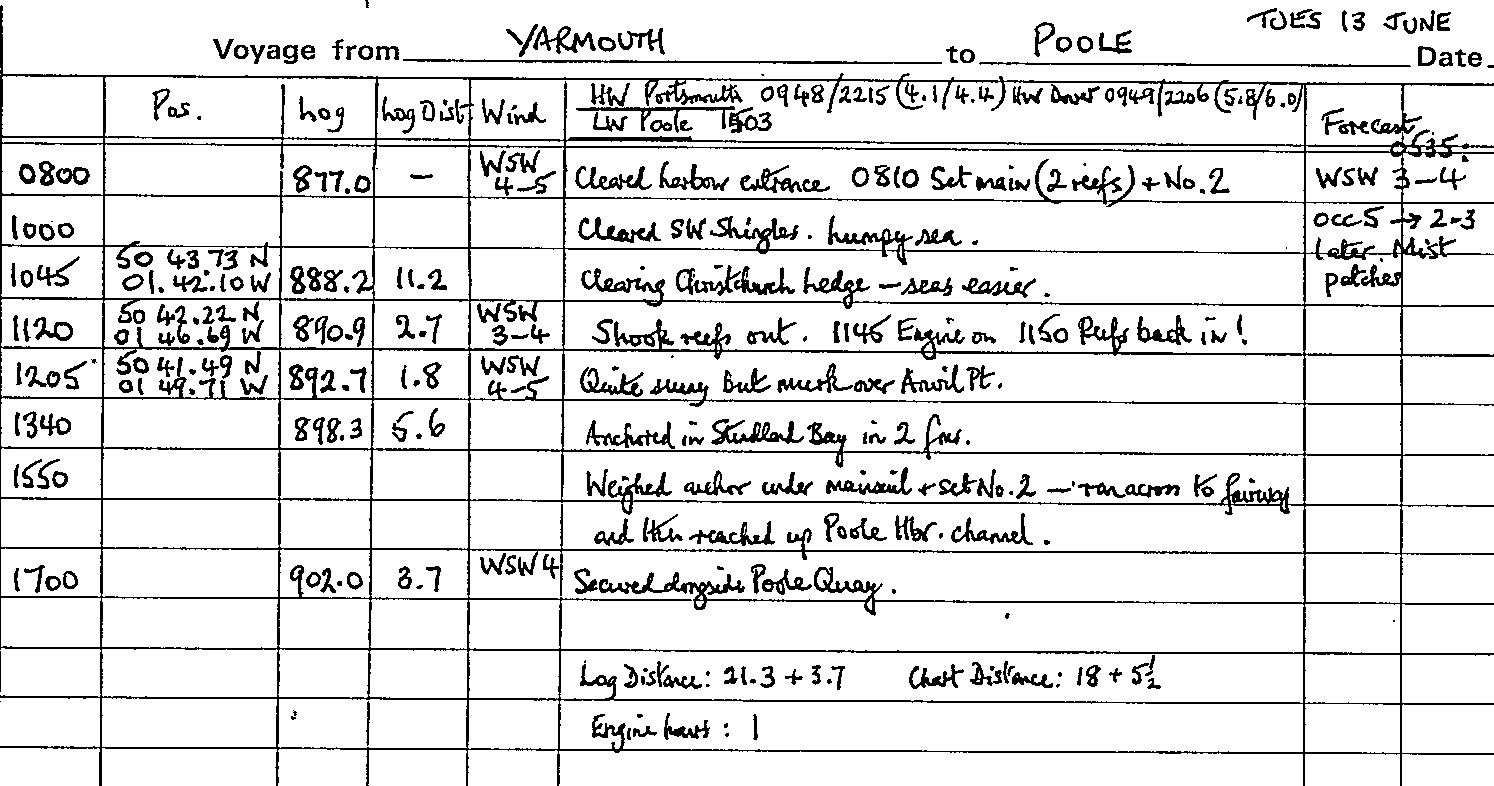
The forecast for the Tuesday was more encouraging with a WSW 3-4, occasionally 5, due to take off later. We left Yarmouth at 0800 and rolled two reefs into the main and set the No.2 genoa. A beat down the Needles Channel was quite a test for Hannah who, though experienced in dinghies, was sailing in open waters for the first time. The previous days' strong westerly winds had left a lumpy sea and progress was quite slow on a grey, murky morning with low cloud sitting over the Island downs. Other boats were following the modern fashion of of motor-sailing to windward. Having cleared the SW Shingles we made a long tack on port - by 1045 we had cleared Christchurch Ledge and in easier seas tacked off the mainland shore near Southbourne.
By 1120 we had shaken the reefs out - but prematurely, because by 1200 a reviving WSW 4-5 persuaded us to roll them in again; the skies were clearing, though Anvil Point was still shrouded in mist. At 1340 we anchored in Studland in two fathoms and enjoyed a late lunch. The skipper was needing to leave the boat for a few days anyway and a forecast of WSW 5-6 for Wednesday morning persuaded us to move straight on up to Poole Quay rather than spend Tuesday night at Studland. We were able to sail our way up through Poole Harbour and by 1700 we were secured alongside the Quay - in time to fend off an errant Horizon 32 which insisted on trying to berth down-tide on the next trot.
Log entries for voyage from Yarmouth to Poole on Tue 13 June
Poole
The next few days were spent profitably by the crew, replacing the faulty GPS antenna and completing new fastenings on the cockpit lockers, as well as putting sealant to good use on the join between coach roof and deck, always a weak spot for leaks into the saloon. The crew also took to bicycles to visit Old Harry and Ballard Down, an expedition somewhat spoiled by thick mist. The Quay provided a peaceful berth at that time of year and in quiet conditions, though weekend power boat traffic coming through the bridge proved more disturbing and facilities are still very limited pending the much delayed improvements that are promised.
Poole - Weymouth
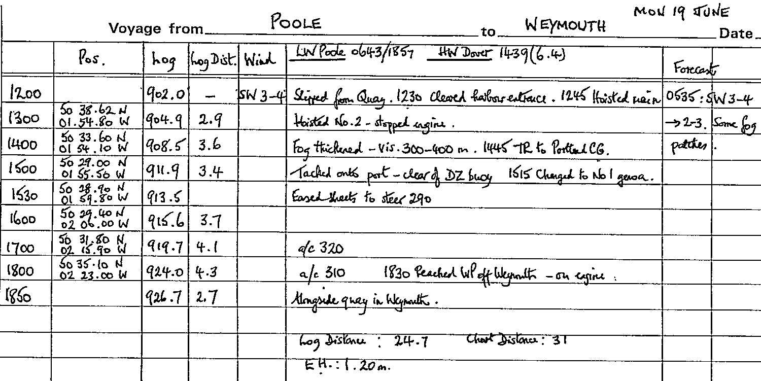
The skipper rejoined the boat on the morning of Monday 19th and, the crew having watered ship and got all ready for sea, we slipped from the Quay at 1200 - having negotiated an ungenerous discount for our stay. The SW 3-4 promised a reasonable passage but visibility was at most two miles and fog patches were forecast. By 1255 we had the outer fairway buoys abeam and set the main and No.2. Within an hour we had lost sight of the Dorset cliffs as we encountered fog and visibility was soon down to 400 metres. Our very effective mouth-activated fog horn was put into action and a call to Portland Coastguard confirmed that visibility there was half a mile. However, only one ship's siren was heard and that passed us at a comfortable distance.
We made a long board out before tacking onto port at 1500 - onto a course to take us comfortably clear of the DZ buoys off St Alban's. We replaced the No.2 with the No.1 to make 4½ knots through the water and, with the west-going tide under us, 7 knots over the ground according to GPS. Progressively we altered course round to 290° and then 310° and were able to ease sheets. Our first sight of land was half a mile off Weymouth and without GPS I am not sure we would have undertaken the passage in such low visibility. We entered harbour at 1830 and by 1850 were secured on the north side on the pontoons just below the Harbourmaster's office. Tinned curry made a quick and tasty supper.
Log entries for voyage from Poole to Weymouth on Mon 19 June
Weymouth
Our stay in Weymouth was longer than expected as a further spell of SW/W winds between Force 5 and 7 set in - not pleasant for the passage to Dartmouth, a view confirmed by the comments of two crews who had come downwind across Lyme Bay and not enjoyed the experience! Weymouth harbour we enjoy more than the marina now that the shower facilities are improved and with plenty of activity to watch; the harbour staff too were more than helpful while we were able to exchange ideas about the weather with the crew of 'Robertson's Golly' (RSYC) also in harbour.
Our time was well spent with James organising a mains power supply to supplement our batteries and make it possible for a laptop to be used for emails - such are the advantages of having two technically-proficient scientists on board! Hannah was trying her hand at sketching boats against the attractive Weymouth waterfront and practising her clarinet in the forecabin. On the Friday we were obliged to shift our berth down-harbour as a rally of Poole Yacht Club boats was booked in; we finished up between one boat from Colchester and another from Wells-on-Sea, Norfolk who had battled further against the prevalent west winds than we had.
Weymouth - Dartmouth
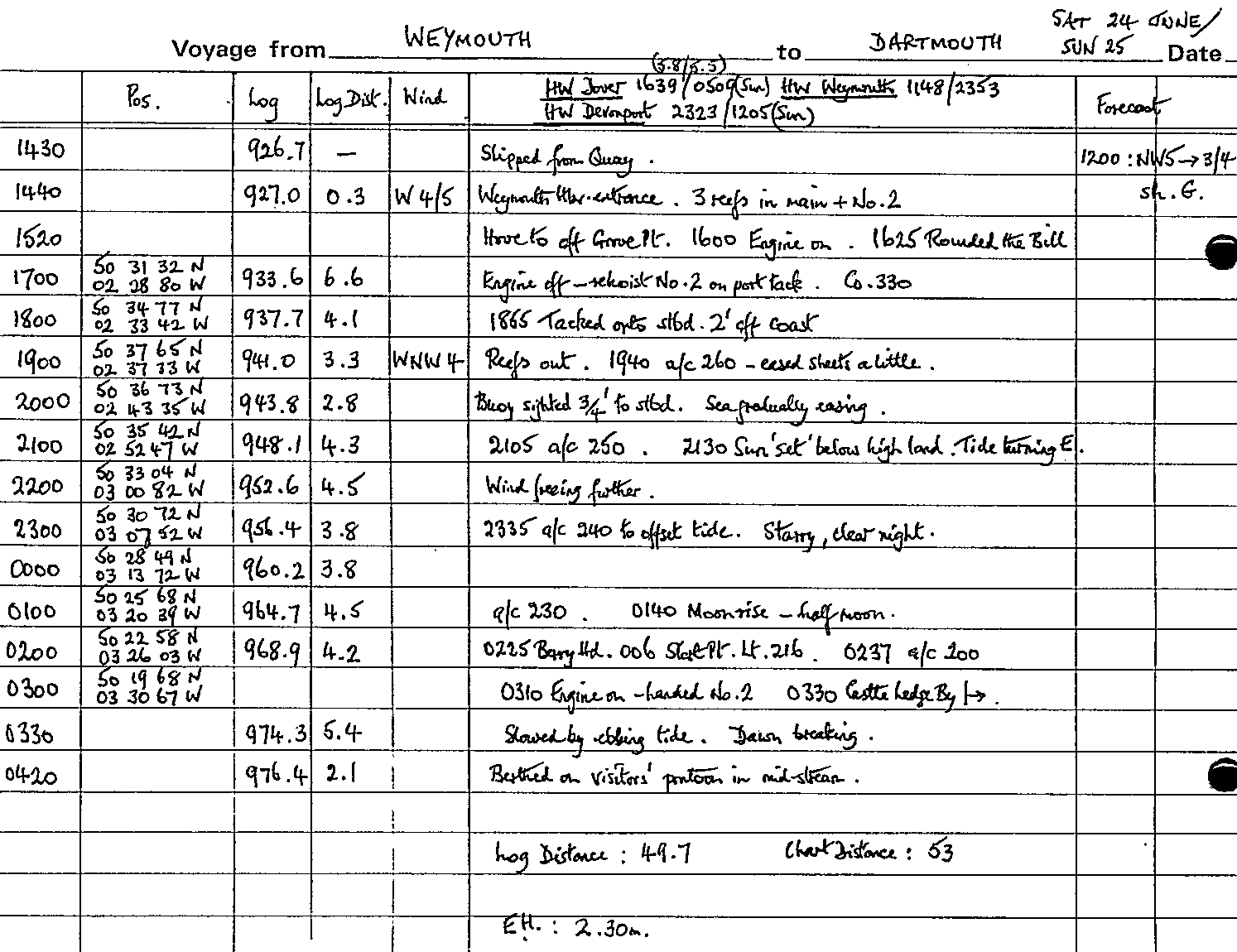
Saturday 24 June brought a better day. We had debated a departure around 0300 to make the inshore passage round the Bill but the thought of negotiating lobster pots in half light did not appeal so we prepared for an afternoon departure and an overnight passage across Lyme Bay. The problem with rounding the Bill by the inshore passage at neaps is that the recommended 'window' tends to occur at an inconveniently early or late hour!
There was still a WSW 4-5 when we motored out and we put three reefs in the main and set the No.2. Anxious to be on our way we in fact left too early, so we hove to under the lee of Grove Point for 20 minutes in order to time our arrival at the Bill correctly. The wind was too shy to be able to lay the inshore passage so we motored in what proved to be an unexpectedly weak south-going tide; the only disturbed water lay outside us and as we rounded the Bill at 1625, a traditional biscuit's throw off, the sun came out. Off the Bill and to the west of it the sea was very lumpy and we had to manoeuvre past a diving boat anchored right on our course - what a place to choose! - and some guillemots. By 1710 we had cut the engine and re-hoisted the No.2 on port tack, heading on a course of 330° for Chesil Beach with sunlit Dorset hills behind.
At 1900 we tacked about 1½ miles off the land and found we were able to lay the course for Dartmouth, which was encouraging. The seas were still quite steep and slowed our progress but gradually, as forecast, the wind veered and eased and we were able to start the sheets. The reefs were shaken out and soon, helped by a weak west-going, we were making 5-6 knots over the ground. It was a pleasant evening sail with an easier motion and hands were piped to a supper of chilli con carne at 2030. The sun set behind the high ground of Devon some 10 miles away and die air turned chill but we forged on despite the tide now turning east, by 0130 lit by a bright half-moon.
Deny Head Light had come up clear on our starboard bow. We bore away further to a course of 220° to counteract the tide and fixes on Berry Head and Start Point confmned our GPS positions. I had expected our arrival at Dartmouth in darkness to present some difficulty but GPS is very helpful and the Castle Ledge starboard hand buoy was picked up very early, as were the leading lights a little further in. We handed the sails at 0310 and motored, albeit slowly, in against the strong ebb just as dawn was breaking. Finding a berth without disturbing anyone was not easy but we managed to squeeze in on the visitors' pontoon in mid-river - just under 14 hours out from Weymouth.
Log entries for voyage from Weymouth to Dartmouth on Sat 24 & Sun 25 June
Dartmouth
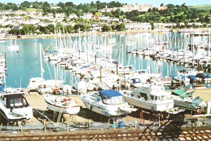
The following morning we shifted berth to the Darthaven Marina as crew commitments necessitated a fortnight's stopover. The marina staff made us very welcome and promised a discounted fee; facilities are good, even though they are a short hike across the railway line, while it is an attractive setting and there is plenty to watch in the busy harbour. We celebrated our arrival here with supper at the Royal Dart YC, enjoyed in evening sunshine on the balcony overlooking the river narrows.
The local store is well stocked, though prices are on the high side, but it is an easy journey by ferry to Dartmouth for greater choice - and for the excellent Harbour Bookshop. James received a great deal of help from the marina-based engineers in trying to trace the fault in our wind instrument - direction was not indicating though speed was: the outcome was that it probably needed a new control unit, at considerable expense, so we decided to live with the defect and depend on our non-technological tell-tales. James also renewed the guard-rail end-fittings, again with much useful advice from a rigging firm in Dartmouth, and he installed terminals from which mobile phones could be recharged from the boat's batteries. James and Hannah also took the opportunity to take a ferry down to Sugary Cove for a swim.
The crew had reassembled by Monday 10 July but once again strong W or NW winds had developed and continued into Tuesday - there was general gloom around the marina about the disappointingly cool and windy summer we were experiencing: boats bound for Cork Week and the Brest Festival were equally held up. However Wednesday's forecast showed improvement with 4-5 for Portland and Plymouth - still from the west of course! - but the inshore forecast suggested 3-4. Our original plan had been to head for the Scillies but the persistent westerlies had blunted that objective and we now considered a crossing to Brittany, thence to St Malo and the Channel Isles. A study of the chart established Salcombe to Tréguier as the best choice, the shortest crossing and east-west tides running somewhat less strongly there than off Lézardrieux.
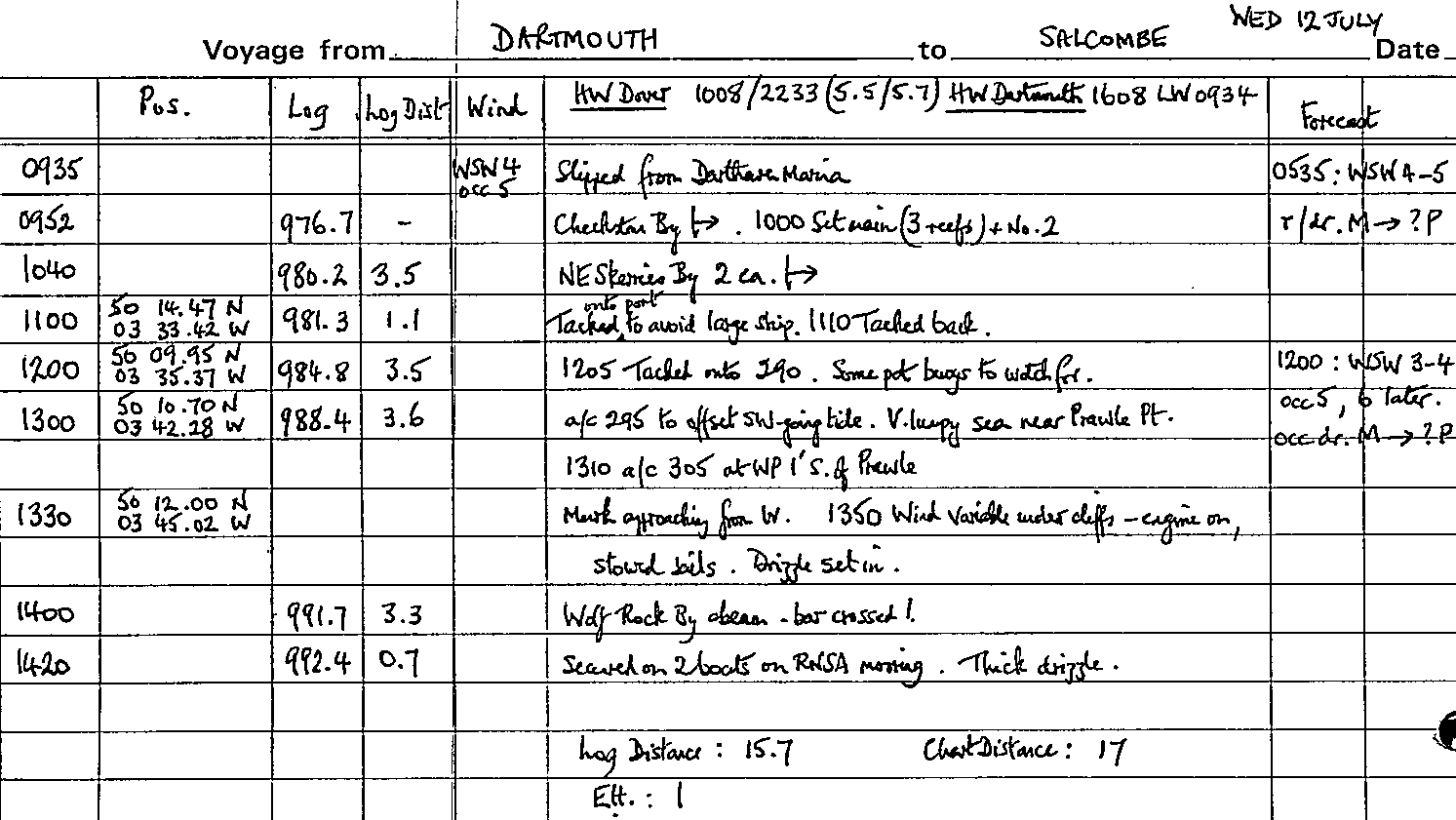
Dartmouth - Salcombe
We slipped from our berth at 0935 with the sun breaking through at times and on our way out rolled in three reefs as a precaution. By 1040 we had the NE Skerries close abeam but then had a long beat to weather Start Point. We had the advantage of tide only until 1330 because to leave Dartmouth earlier would have meant arriving at Salcombe bar at the bottom of LW Springs, which is not recommended. However by then we had closed the entrance to Salcombe, Bolt Head looking bleak but majestic in the developing murk. We lost the wind under the cliffs and in drizzle handed the sails, crossing the bar under power at 1400 and proceeding up harbour to the RNSA mooring off Snapes Point, just above the town. There we rafted up on 'Goblet', a Nicholson 32, and another boat as the drizzle thickened. The Avon was soon launched for the first time on our cruise and the Suzuki outboard fired first time!
Log entries for voyage from Dartmouth to Salcombe on Wed 12 July
Salcombe
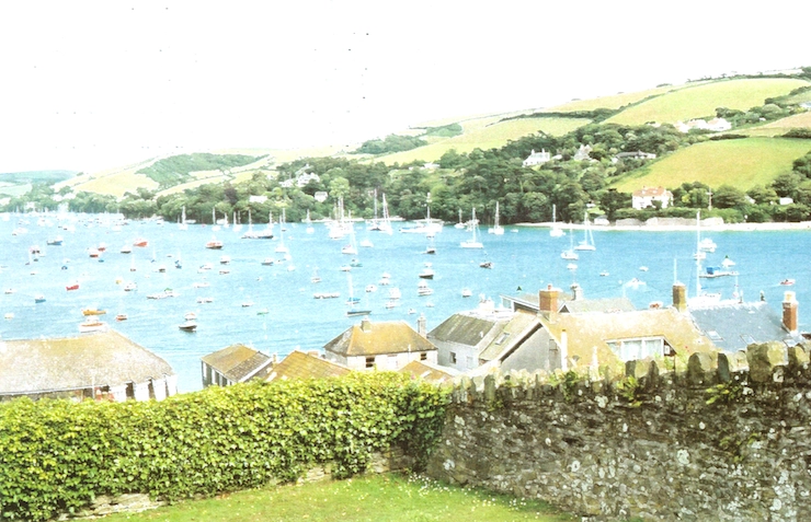
An expedition was made ashore for stores but the harbour staff were floored when asked where email facilities might be found, not realising that the local library was in fact well provided! The WSW wind against the ebb made for an unpleasant roll until 2100 and then restarted from 0530 on Thursday, with some heavy thuds on the Nicholson's fenders. Discussions in the morning with the helpful Harbourmaster and 'Goblet' about forecast winds of W/NW 6-7 persuaded us to move and we found a mooring near to the town, therefore more sheltered and without being rafted up - though without the RNSA discount!
There was plenty of blue sky on the Thursday and Friday but with a blustery NW wind blowing a good Force 6. Showers were found at the Salcombe YC, while James and Hannah took the Avon down to South Sands and walked out to Bolt Head one day and swam from Mill Bay the next. Decreasing NW winds (ideal for our crossing) were forecast for Saturday but we decided to leave in the afternoon, at high water, to give the weather and the sea 12 hours to settle and to give us a landfall in daylight.
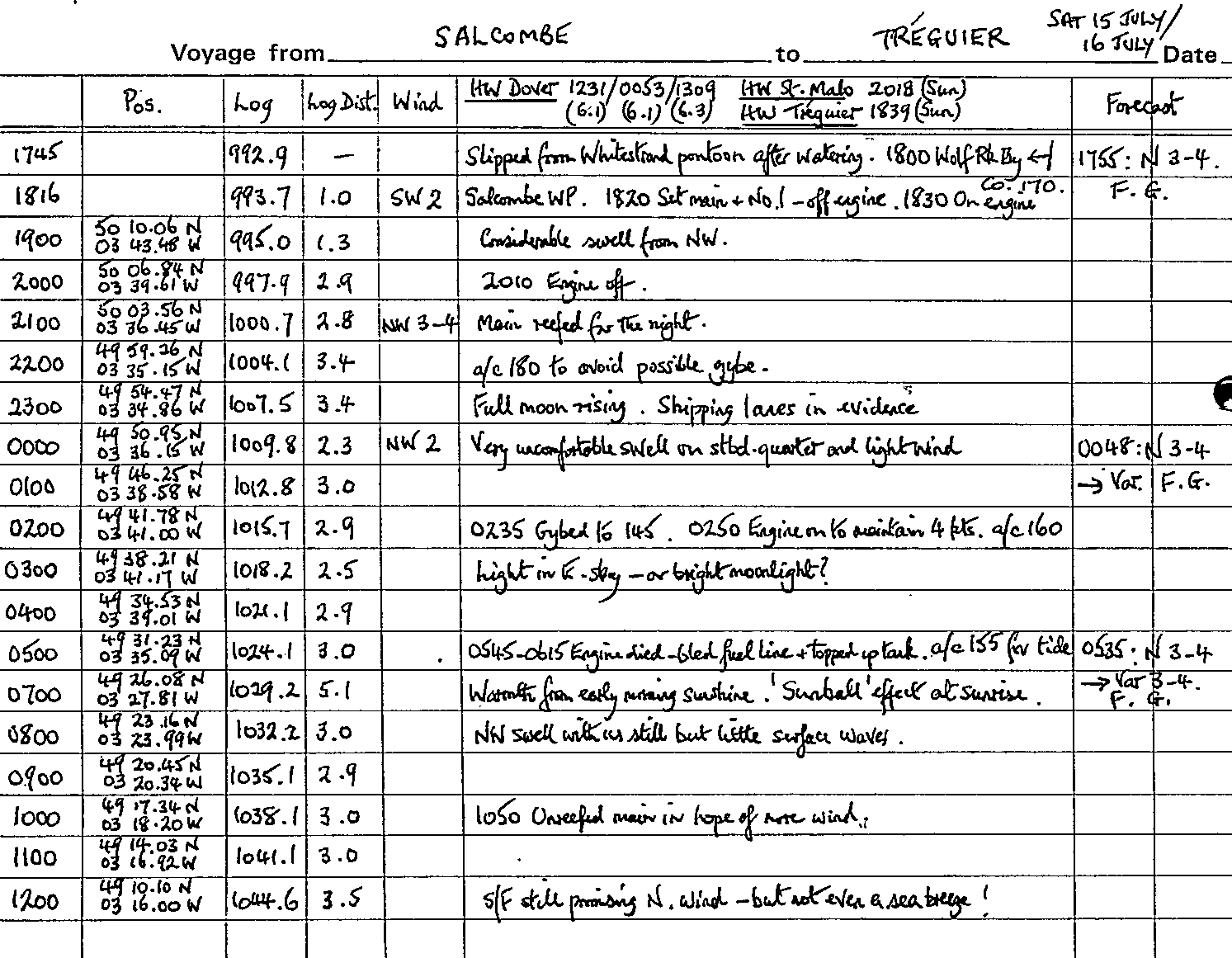
Salcombe - Tréguier
Sure enough, by Saturday morning the wind had taken off and in fact by afternoon a sea breeze had set in from the SW! We slipped our mooring and took on water from the convenient Waterstrand pontoon; by 1745 we were motoring down the estuary as a procession of boats were pouring in for the weekend, some trebling up on moorings and others anchoring. By 1815 we were clear of the entrance and leaving the Devon coastline behind, looking beautiful in the bright evening sunshine. We set the main and No.1 but disappointingly the wind was light from the NW while there was inevitably a considerable swell running, left by the winds of the last few days. However it was lovely to see gannets in flight and on the water, a reminder that we were now in Western Channel waters. After a good supper of chilli con carne the wind picked up and we rolled three reefs in the main for comfort during the night; we also came round to a course of 180° to make an involuntary gybe less likely.
By 2300 the full moon was rising and we were approaching the first down-Channel shipping. The wind had fallen away again and there was no sign of the N 3-4 still being forecast at 0045. We were no longer maintaining 4 knots through the water so switched the engine on at 0250. The early hours passed very pleasantly with the bright moonlight and little shipping to bother us apart from the occasional fishing boat. The engine spluttered to a halt at 0545 - a recurring problem when the level of fuel in the tank falls below halfway, especially when the boat is rolling. We topped the tank up from the can, James bled the fuel pipe and we were soon under way again, but we were beginning to wonder whether we would have sufficient fuel if we had to motor all the way. By 0700 the sun was beginning to exude real warmth and we observed the phenomenon of 'sun dogs' when there appear to be two bright spots either side of the sun, the effect of ice crystals in the atmosphere. There was still a significant swell but surface of the sea was still glassy.
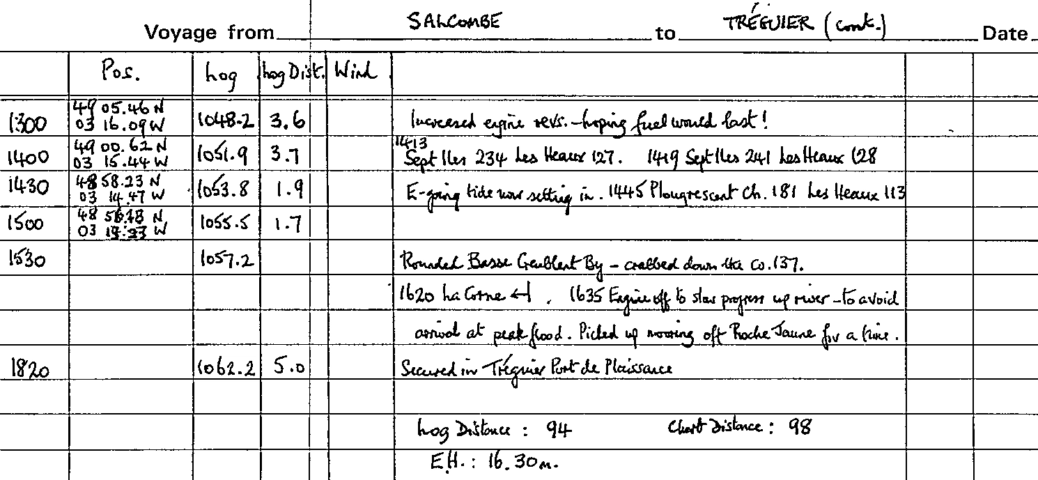
During the day there was not a breath of wind, and no sign of an onshore sea breeze which we hoped might develop from the north as we approached the French coast, especially as the midday shipping forecast still spoke of a N 3-4! By 1400 our navigator was straining his eyes for the Basse Crublent buoy - rather optimistically because there was considerable haze. A visual fix on the Les Sept Îles and Les Héaux de Bréhat lighthouses confirmed our GPS position and we headed in for our first Breton landfall - not an impressive one because the coastline is comparatively low. The change of tide was at 1430 so we had timed it quite well making our approach from the NW as the east-going tide began to make. Though it was neaps, nevertheless it was surprising how quickly the tidal set increased and we were pleased to reach the Basse Crublent buoy by 1530.
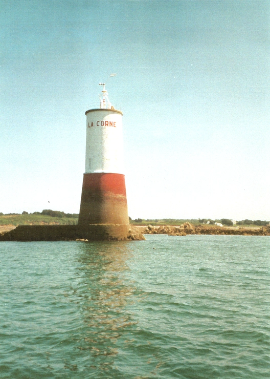
Even the daymarks were visible and the Grande Passe was negotiated without any real difficulty, although with the fuel level in the tank dropping and still no wind we were trusting the engine to keep going as we crabbed across the strengthening tide through the narrow part of the channel by the Pierre de l'Anglais. Soon however we were leaving Petit Pen ar Guézac to starboard and into the estuary proper, leading to the Tréguier River. The pinky colour of the rocks of this Côte de Granit Rose was now much in evidence as we motored our way up-river past the solid white lighthouse of La Corne.
As high water at Tréguier was not until 1839 and the pilot warned of the strong tide at the marina, we switched the engine off to drift slowly on the flood. Off the sleepy little village of La Roche Jaune we picked up a mooring - but had to drop it in a hurry when a shout warned us of the approach of a local gaff cutter without engine. Interestingly she proceeded to come down-tide at some speed dropping her sails, the bowman picking up up the mooring holding on for grim death as she swung 180 degrees - he'd obviously done it before! Meanwhile we drifted on up-river on the tide at a leisurely 1½ knots, past the peaceful wooded banks somewhat reminiscent of the Medina River above Cowes. The lovely old manoir was passed and then the soaring, pierced spire of the St Tugdual's cathedral high upon the hill in Tréguier came in sight.
By now it was half an hour before high water and we berthed easily into the last of the flood tide, 25½ hours and 94 miles out from Salcombe. It was all very quiet but unfortunately we had chosen a berth with only a short finger. Within an hour or two the ebb was running at 2-3 knots and as our spring and stern rope had little purchase the boat swung part-way across the berth, the warps straining noisily and worryingly. The usual spectators arrived from other boats nearby to offer comments and advice, but all we could do was to grit our teeth and wait for the change of tide. We gathered that we were not the first boat to suffer from these particular berths and we were quick to move ourselves to a better one at slack tide the next morning.
Log entries for voyage from Salcombe to Tréguier on Sat 15 & Sun 16 July
Tréguier
Tréguier we liked. The marina was quiet and only half-full. The town is ancient with a charming central square dominated by the cathedral and full of life, once you have climbed the hill. Some fine half-timbered houses remind you how important and wealthy a trading port this was, especially in the XV and XVI Centuries. The weather had now improved and we enjoyed our baguettes and cheese in the cockpit in hot sunshine. We spent Monday 17 July getting stores and refuelling. We also crossed the Pont Canada above the marina to visit the Co.Per chandlers, reputedly one of the best in Europe and which, situated in an old tide-mill and with its smell of tarred rope and rows of wooden blocks, did not disappoint.
Tréguier - Lézardrieux
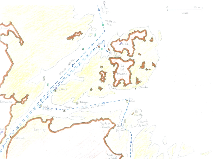
We had now, on account of time and with some regret, determined to turn our backs on Western Brittany and to head east - first stop Lézardrieux, about which we had heard so much. Hot sunshine, variable winds and possibly fog patches were now to be the order of the day. We dropped down river on the last of the ebb and found a least depth of 14', in fact mostly 20' to 35'. Off La Roche Jaune we picked up a mooring and had some lunch, a NNE 3 sea breeze filling in to give us some wind but (the story of our cruise) on the nose! At 1435 we slipped from the mooring, motored down river against the first of the flood and rounded Petit Pen ar Guézac to take the Grande Passe outward (we had decided against the short-cut, the Passe du Nord Est).
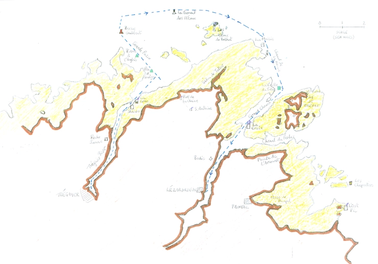
The tide was still west-going but by the time we had rounded Basse Crublent at 1608 it was east-going. The rocky coast was wrapped in some mist but La Jument was rounded without difficulty. Soon we were making 7-8 knots over the ground. As we passed the tall Les Héaux de Bréhat lighthouse we edged our course round to the SE as we had decided to take the Moisie Channel into the Trieux River, despite some warning notes in the pilots. We left the Moisie E-cardinal beacon tower half a cable to starboard and picked up the leading line, making good 165°. The sight of the jagged reefs extending NE from Sillon de Talbert and the spring tide pouring across them was quite unnerving and once again we felt very dependent on the engine as there was hardly any wind, especially as we passed just west of three drying rocks with a fierce cross-tide.
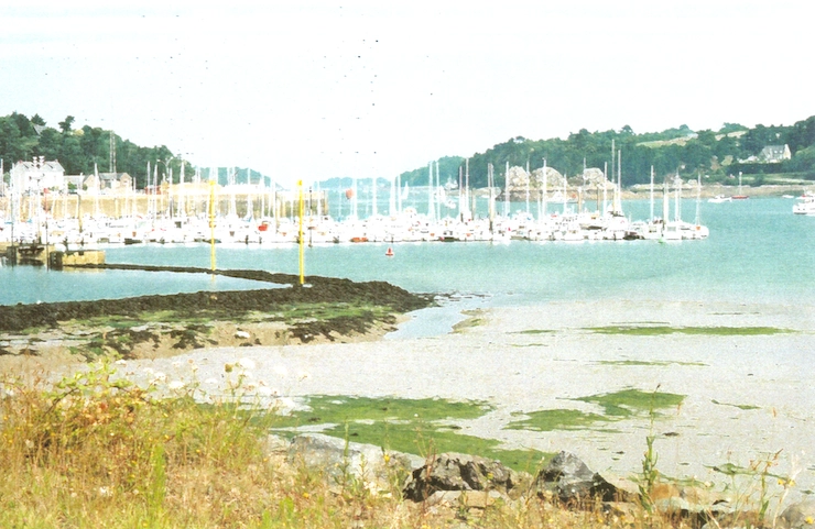
The starboard hand beacon of La Vieille du Tréou was rounded at 1742 and we were into the Trieux River itself with the Île de Bréhat on our port hand. With the flood tide under us we motored our way up river past La Croix light beacon with its red crenelated top and then on between steep, wooded banks. Just short of Perdrix, at 1835, the engine failed us but it was a quiet stretch of river and we were able to pick up a mooring and bleed the fuel pipe through (better here than in the Moisie Channel!). Arriving at the more crowded Port de Plaisance de Lézardrieux we were found a berth - the tide did not set nearly as strongly through the pontoons here as it had at Tréguier.
Log entries for voyage from Tréguier to Lézardrieux on Tue 18 July
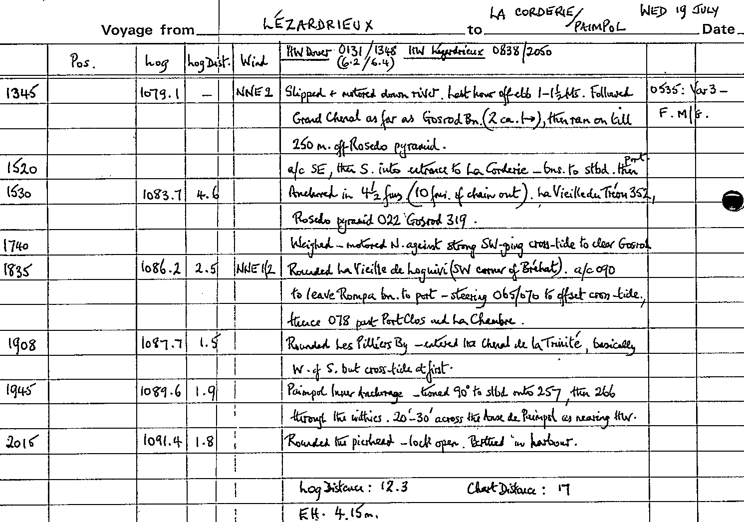
Lézardrieux - Île de Bréhat
Climbing the hill, we spent the morning of Wednesday 19 June buying stores at the small Casino supermarket, just off the the wide and sleepy town square. It was all very quiet in the hot sunshine.
After an early lunch we slipped out at 1345 and motored down river, avoiding numerous fleets of sailing school dinghies - the French certainly go to great lengths to introduce their youngsters to the sport. We had decided to spend the afternoon at La Corderie, the narrow inlet which almost divides the Île de Bréhat in half. Following the Trieux River down as far as the white pyramid daymark, Amer du Rosédo, we turned to starboard to the SE, then S, to enter the secluded anchorage. The approach was well marked with port and starboard spar beacons and although it was LW springs we edged well in and brought up in 4½ fathoms with 10 fathoms of chain out.
There were eight other boats in this attractive anchorage nestling on the NW side of the island. Hannah had a swim, successfully trying out our new MOB recovery ladder. Just as we were due to leave we were hailed by an old friend from Shoreham - we had a chat but could not stay longer, sadly, as they were spending the night there.
Île de Bréhat - Paimpol
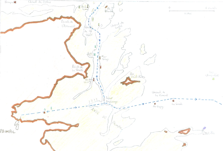
We weighed at 1740 and as it was half flood had to motor out across a very strong cross-tide to rejoin the main channel and turn upriver. SW of Bréhat and just past La Croix lighthouse we swung hard to port to round La Vieille de Longuivy W-cardinal buoy at 1835 and enter the Ferlas Channel which runs east-west between Bréhat and the mainland. We were bound for Paimpol and were hoping to fmd favourable tide. However it was not to be as the strong cross-tide seemed to be on our port bow as we headed east.
We reached Les Pilliers beacon tower at 1908 and found our way into the Chenal de la Trinité which leads south, then south-west, from there. This channel is described as 'intricate but well marked' and both were true, with GPS once again proving valuable for the zig-zag course that was needed; out to port of us lay a typical North Breton seascape of rocky islets of granite lit by the evening sun. When we finally reached the Anse de Paimpol at 1945 and turned 90 degrees to starboard onto a course of 266° we still had three miles to go. Steering straight into the setting sun we identified the leading line and with plenty of water over the flats which dry out at LW we had a straightforward run to the Paimpol pierhead. The lock was open and someone came straight out from the Capitainerie to lead us to a berth.
Log entries for voyage from Lézardrieux to La Corderie and then Paimpol on Wed 19 July
Paimpol
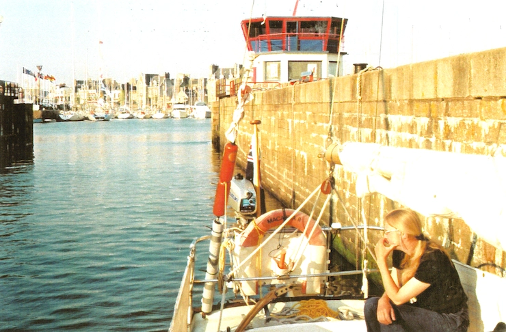
Paimpol, a former deep sea cod-fishing port, is more of a working dock basin than a marina; it is located in the heart of the busy town and has lots of atmosphere. We had hoped we might have been able to replace our spare Calor gas cylinder as our current one was getting low, but of course here, as elsewhere in France, there was only Camping Gaz. Thursday was another sunny day and we were intrigued by the French boat next to us, a 25-footer, in which the skipper seemed to hold court with four women under a sail stretched over the cockpit as an awning, cooking with tantalising smells and stitching a sail - both activities being accompanied by gales of Gallic laughter. That evening we took ourselves ashore for an aperitif in the late sunshine, followed by a tasty meal at the Restaurant du Port.
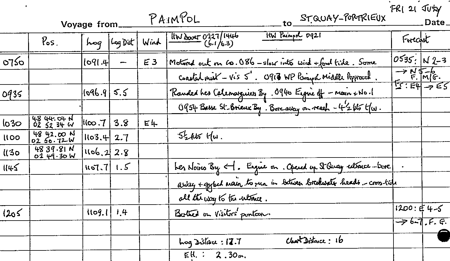
Paimpol - St Quay
Friday 21 July brought an early start: we left our berth in bright sunshine at 0710 but just missed the lock opening so waited on the adjacent pontoon until 0750, to be joined by several other boats.
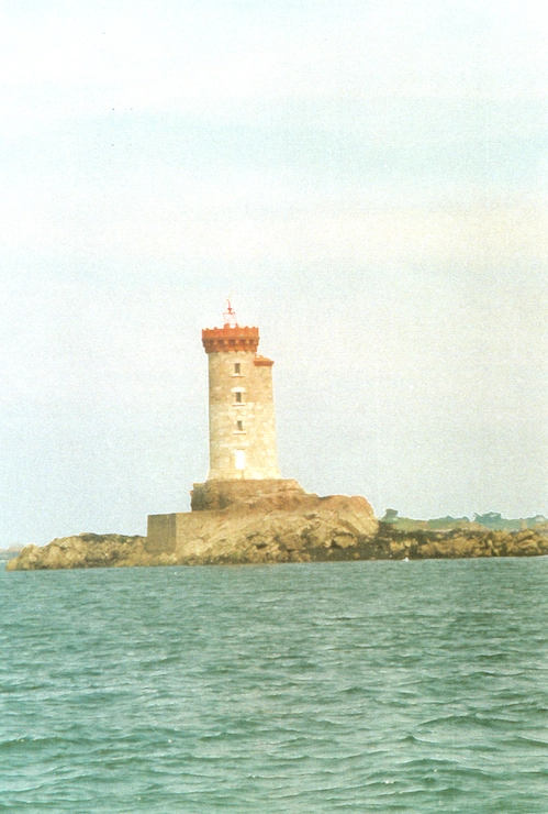
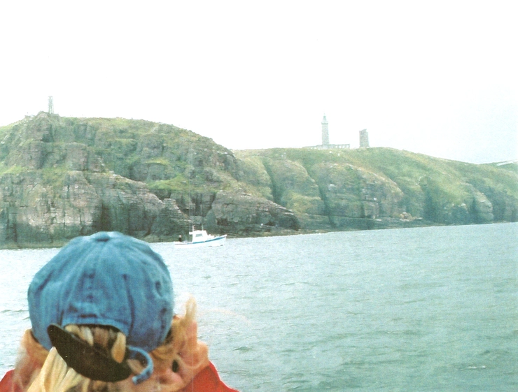
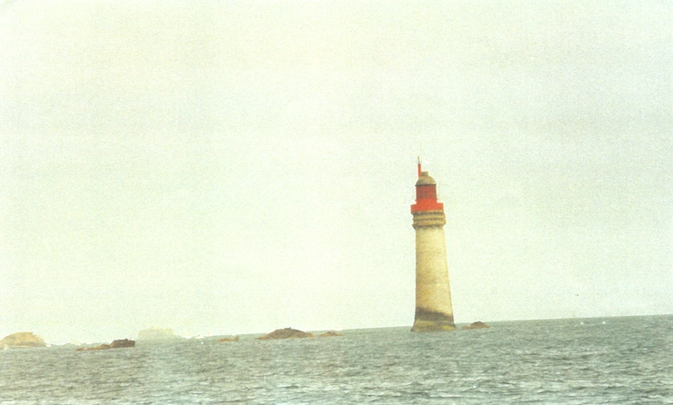
The wind was a pleasant Force 3 but inevitably from the east which necessitated motoring out along the approach channel on a course of 086°; there was a depth of only 7-8' at first but soon we had 13' or more under us. Progress into a slight head sea was comparatively slow: local HW was at 0921 so we had a flood tide to contend with as well. By 0910 we were able to ease away to starboard enough to make it worthwhile to hoist the main and at 0935 we rounded the Les Calamarguiers buoy with L'Ost-Pic lighthouse, white and four- square, prominent on its rock - French lighthouses always seem to have a lot of character.
We could at last switch the engine off and set the No.1; after rounding the Basse St Brieuc buoy we were reaching in a Force 4 - grand conditions of bright sun and a sparkling sea as we tramped along at 5 knots over the ground despite some foul tide. Enjoyable sails never seem to last long and by 1120 we were entering the Rade de St Quay with the Madeux beacon away to port at the head of the Roches de St Quay. Passing close to starboard of Les Noires buoy we reached on for another half mile before gybing and broad reaching in over what was now a strong north-going cross-tide to make the marina entrance between the massive breakwaters - as the wind piped up to a Force 5.
Finding a berth was straightforward in this vast marina with a total of nearly a thousand berths. The shower block was a bit of a hike but well worth the walk.
Log entries for voyage from Paimpol to St Quay on Fri 21 July
St Quay
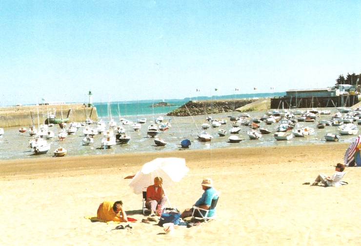
Forecasts of strong winds for the next few days had encouraged us to make for St Quay and although still sunny the wind was up to Force 6 or 7 by the evening. It blew hard from the ENE all Saturday and into Sunday, albeit out of a blue sky, but despite continuing forecasts of 5-6, occasionally 7, it had fallen away to a 4 by Sunday afternoon. We had made several excursions ashore - for stores in the attractive old fishing port of Portrieux and round to the resort of St Quay.
The Capitaine du Port had warned boats of thunderstorms moving up from the south but it was not until evening that thundery rain set in - and how it rained! - all night and all the next morning to the extent that several leaks were rediscovered. 'Quel temps!', as the woman remarked at the shower block, and Radio 4 reported that Guernsey had had over an inch of rain overnight. We had contemplated a departure on Monday because the wind was down to a 4 or 5 but on the nose (NE) and the continuing rain and poor visibility helped to dissuade us. It still drizzled through the afternoon but the forecast suggested that our resident low over Northern France was at last moving away to the east.
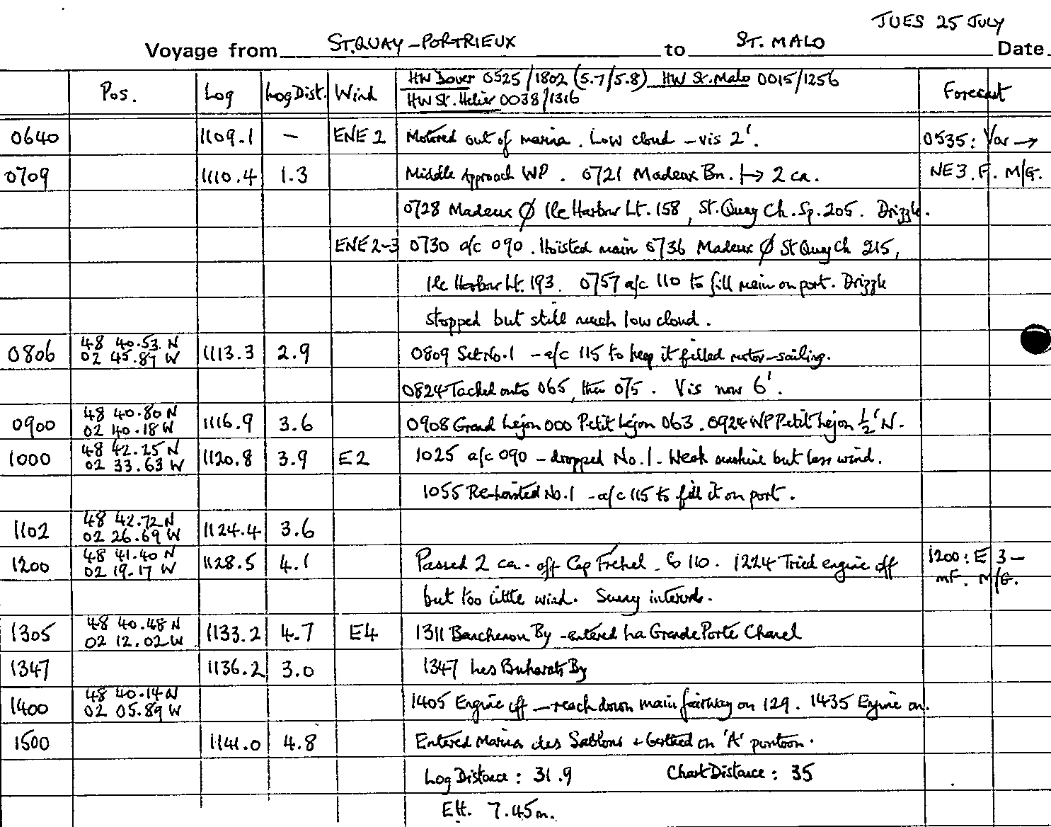
St Quay - St Malo
At 0640 on Tuesday 25 July we slipped out of our berth and headed out, leaving behind happy memories of a pleasant, well-supplied marina, even if the attractions of the town had palled after a day or two. Visibility was only two miles with low cloud and drizzle in the air. We took the north channel and by 0720 had rounded Île Harbour lighthouse and the Madeux beacon marking the outlying rocks. With a light ENE 2-3 it was case of motor-sailing,especially as we had decided to make the full stretch to St Malo. We had contemplated a visit to Dahouet but that would not have got us far east and time was beginning to be a factor, or to anchor off Erquy (open to the west) or St Cast (open to the east) when the wind was due to back to the NW. At 0800 we altered course to 110° in order to fill the main on the port tack and so give us better speed - our economical cruising speed with engine alone is little better than 3½ knots. Ten minutes later we were hoisting the No.1 genoa and by bearing away to 115° filled that usefully as well, which gave us an extra ½ knot. 15 minutes later we were headed so tacked onto 075° still motor-sailing.
Visibility had improved to about 6 miles so the Petit Léjon buoy, close on the port hand, and the Grand Léjon beacon further to the north were in view; the coast however remained a misty blur. By 1000 we had made 13 miles; the sun shone weakly but the wind fell away so we dropped the No.1 and motored the direct course of 090° - with a slight detour to avoid a troublesome trawler. We refilled the fuel tank from the can to keep it well up and by 1100 were able to re-set the No.1 and fill it on the port tack on a course of 115°, which was fine as we were by now somewhat to the north of our intended track. Across the Baie de St Brieuc the tide had been setting across us to the south but approaching Cap Fréhel it was more favourable, though due to change at 1300. Keeping the sails full took us close to the islet of Amas du Cap and past Cap Fréhel itself, an imposing headland crowned by a squat lighthouse with apparently crowds of sightseers swarming over it. It was now 1200.
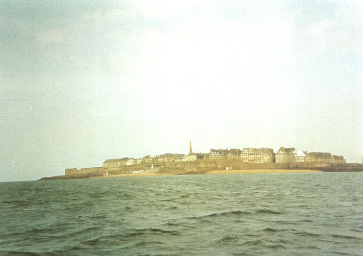
By 1310 we had covered the 5 miles to the Banchenou buoy, which marks the beginning of the Chenal de la Grande Porte; the stone walls and buildings of St Malo, lit by sunshine, were beckoning on our starboard bow. The approach was straightforward and once we had rounded Le Sou buoy, opposite the tall Le Grand Jardin lighthouse, we were able to sail, close reaching down the Chenal de la Petite Porte at 5 knots or more in an easterly 4, the sun now fully out on a perfect afternoon.
St Malo
As we were intending to stay only one night we opted for the Anse des Bas Sablons, which we entered at 1500, eight hours out from St Quay, and quickly found a berth on the visitors' pontoon. In retrospect we should have chosen the Bassin Vauban, even though it meant locking in but we were arriving and departing around HW anyway. At least the marina meant the food shops of St Servan were not too far away, but generally the marina facilities were not very attractive, especially as we had an hour's thundery rain in the evening.
Log entries for voyage from St Quay to St Malo on Tue 25 July
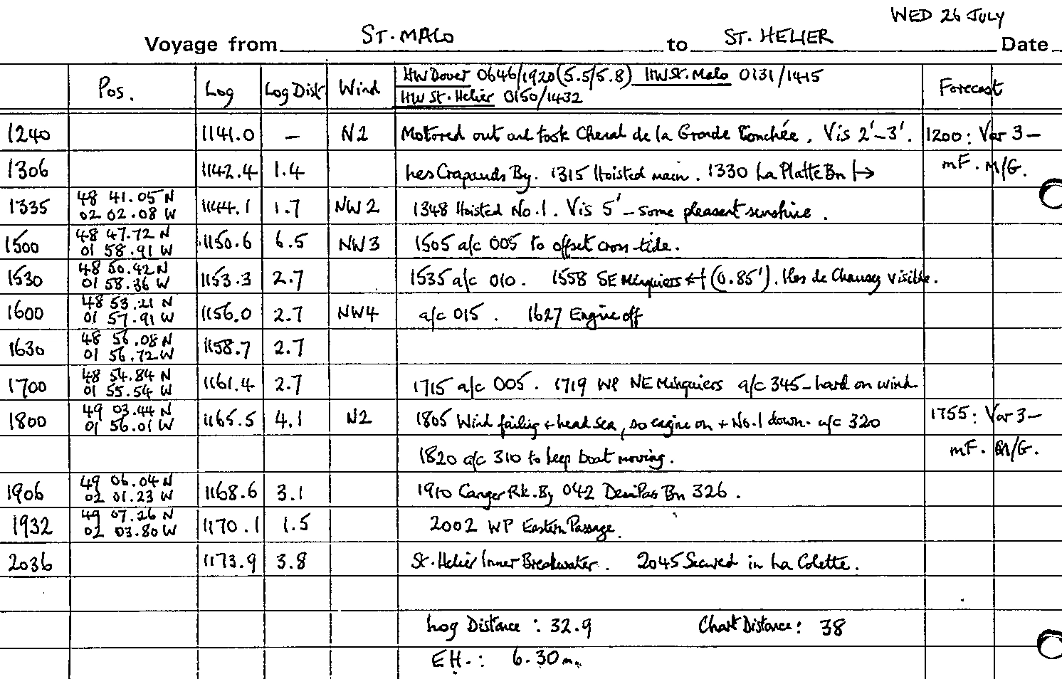
St Malo - St Helier
Our next port of call was to be St Helier and as the optimum time for departure was midday James and Hannah took a walk round to view the old city of St Malo, while the skipper collected some more diesel and greased the stern tube. Forecasts were not very helpful, suggesting the possibility of fog and a northerly 2 which was supposed to back towards the SW. As the forecast for the next day was for worse visibility we decided to go; we slipped from the marina at 1240 with visibility between two and three miles. To save time we took the Chenal de la Grande Conchée, especially as it was an hour before HW, and found it easy enough in the quiet conditions. We rounded the Roche aux Anglais and by 1330 had La Plate beacon abeam to starboard. There were now pleasant intervals of sunshine and visibility had improved to five miles. With a NW3 we motor-sailed making 5-5½ knots through the water; by 1535 we had borne away to a course of 010° to allow for what was becoming a cross-tide from east to west.
At 1600 we had the SE Minquiers buoy just under a mile on the port beam and the Îles Chausey were in sight to starboard about six miles away. The wind had now perked up to a Force 3-4 but with no sign of it backing beyond NW; nevertheless we switched the engine off and by 1720 the NE Minquiers buoy was close on our port beam - over 6 knots made good since 1600 thanks to the NW-setting tide. Our course for St Helier was now 320° but we could only lay 345°. Soon the wind was taking off and a lumpy head sea was slowing us to three knots through the water. So at 1805 it was back to motor-sailing without the genoa and heading 320°. The coast of Jersey was showing up in the evening sunshine - the Canger Rock buoy and the Demie de Pas beacon tower soon being identified. We took the Eastern Passage in and by 2035 were passing the inner breakwater to the harbour - 9 hours out from St Malo and 38 miles covered. As it was getting near to LW the marina was not accessible so we turned hard to starboard into La Collette yacht basin and found ourselves a berth alongside a Moody 346 from Parkstone YC. The basin offers a pleasant, quiet berth and has good facilities but is a little distance from the town.
Log entries for voyage from St Malo to St Helier on Wed 26 July
St Helier
The following morning, Thursday 27 July, we shifted berth in bright sunshine from La Collette into St Helier Marina, the sill opening at 1240 and not 1120 as our Moody neighbour had informed us! We berthed on E pontoon and were soon ashore for stores and in particular a replacement Calor cylinder. The weather remained fine on Friday: the crew hired bikes on which they visited Gorey to the east and Bonne Nuit Bay to the north; they found the island provided something of an up-and-down course! The town of St Helier was a bustle of activity, crowded with tourists and traffic. High pressure was building but unfortunately we were due for another stop-over while we returned briefly to the UK.
By Tuesday afternoon we had reassembled but by now of course the forecast was for SW 5-7 so we remained harbour-bound under a blue sky with a full Force 5, while Thursday passed in similar vein. Our enforced stay in St Helier, now prolonged, was frustrating and there were many other boats similarly weather-bound, but by Thursday evening the forecast for Friday was encouraging, though the wind was still likely to be NW in direction and therefore once again on the nose!
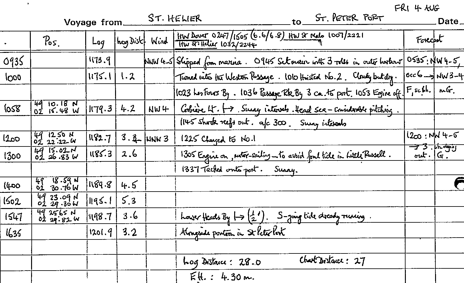
St Helier - St Peter Port
Sure enough, the lighter Force 4-5 on Friday morning was from the NNW. It was cloudy but dry as we set sail at 0945 with three rolls in the main and the No.2 genoa. The 'Western Passage' took us on a course of 266°, close past the Noirmont Point lighthouse with its black and white striped tower and with the Les Fours buoy to port marking offshore rocks.
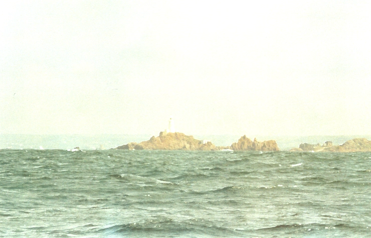
With a favourable weather-going tide and a heavy swell left by the previous days' wind we were pitching considerably but nevertheless making good over 5½ knots. By the time we had La Corbière lighthouse abeam just under a mile away at 1100 the rocky coast was bathed in sunshine. The course required from here was 334° but the best we could lay was 300°.
The wind soon fell away to a Force 3: by 1230 we had shaken out the reefs and set the No.1. The head sea was still preventing 'Macaria' from getting into her stride and even with favourable tide we made only four miles in the hour to 1300. To avoid the worst of the adverse tide in the Little Russel we had to keep our speed up - so it was back to motor-sailing. It is difficult to get your tides right on this particular passage and what was now a west-going tide was pushing us well to the west of our required course. At 1335 we tacked onto port, probably a little too late, and we struggled to make the Little Russel; at last, at 1545, the Lower Heads buoy was a mile away on our starboard beam.
We had been surprised to observe several boats making close into St Martin's Point as we thought they would have to contend with a west-going tide there, but clearly there was an eddy to help them - local knowledge does help! The south-going tide was running hard and it took us until 1625 to make the two miles to the entrance to St Peter Port. The efficient port staff were on hand to direct us to a pontoon berth - we felt it was not worthwhile waiting to enter the marina. We got ashore just in time to buy essential stores before the shops closed.
Log entries for voyage from St Helier to St Peter Port on Fri 04 August
St Peter Port - Sark
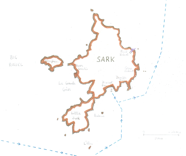
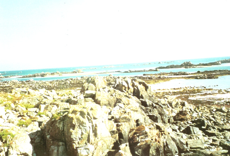
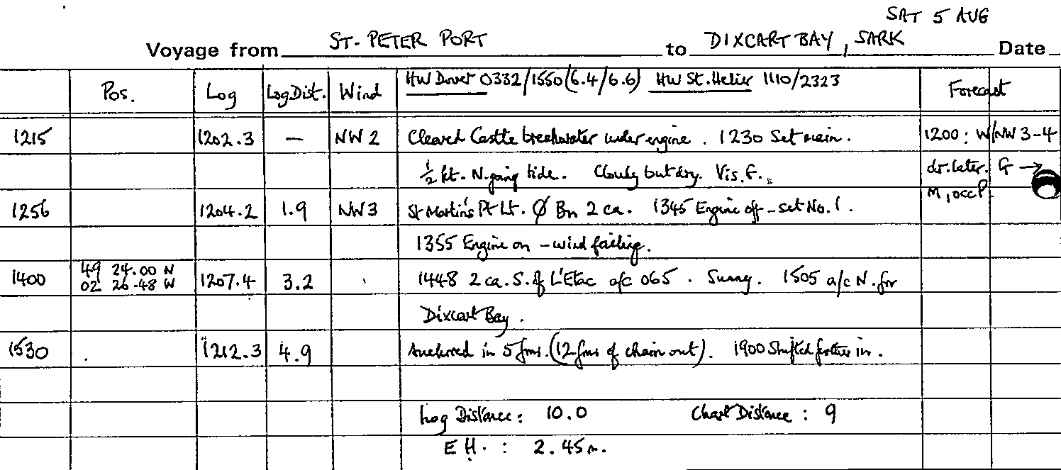
A peaceful night was followed by an excursion ashore on Saturday morning, 5 August, - for showers and some duty-free - before departure. We sailed at midday, bound for Sark as the crew were keen to renew acquaintance with it and conditions seemed good. There was a ridge of high pressure establishing itself across SW Britain but a low in Iceland threatened warm troughs. The N-going tide was not as strong as we expected and under power we slid easily down the coast past Fermain Bay to St Martin's Point, which was abeam at 1255. From there we headed ESE. We tried switching off the engine at one stage but the NW 2-3 was on our quarter and gave us little speed.
It was a drowsy, somewhat hazy but sunny afternoon with good visibility and the high cliffs of Sark soon loomed over us. At 1448, ¼ mile S of L'Étac off the southerly end of the island, we came round to 065° until we could head N for Dixcart Bay which we had selected as an anchorage - a bit of a toss-up with its neighbour Derrible Bay.
Log entries for voyage from St Peter Port to Dixcart Bay, Sark on Sat 05 August
Sark
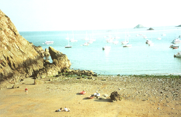
Peter Cumberlidge describes Dixcart as 'ideal in NW winds', and 'an attractive and secluded bay'. At 1530 we anchored in five fathoms of water with 12 fathoms of chain out; there were two or three dozen boats already anchored but we found space without difficulty. We took ourselves ashore in the Avon and made the steep climb up the wooded path from the beach to the town which with its dusty road and no cars 'has something of an outback flavour'. We treated ourselves to a cream tea and then walked across the island to look down on Havre Gosselin where Hannah had spent holidays as a child - with the sun near to setting it was magical.
Returning aboard at 1900 we found the boat rolling heavily in the 1½ knots of tide, so we weighed anchor and moved closer in,about 1½ cables from the beach where the depth was 3 fathoms at LW. We let out 18 fathoms of chain ready for the 7 fathoms depth there would be at HW but were a little worried about a nearby French boat. Even here we continued to roll in a strange way because there was little discernible swell and the wind was offshore. It wasn't a very restful night and we wondered whether it was always like that here.
Sark - Alderney
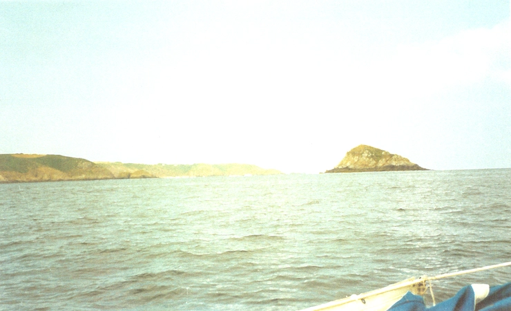
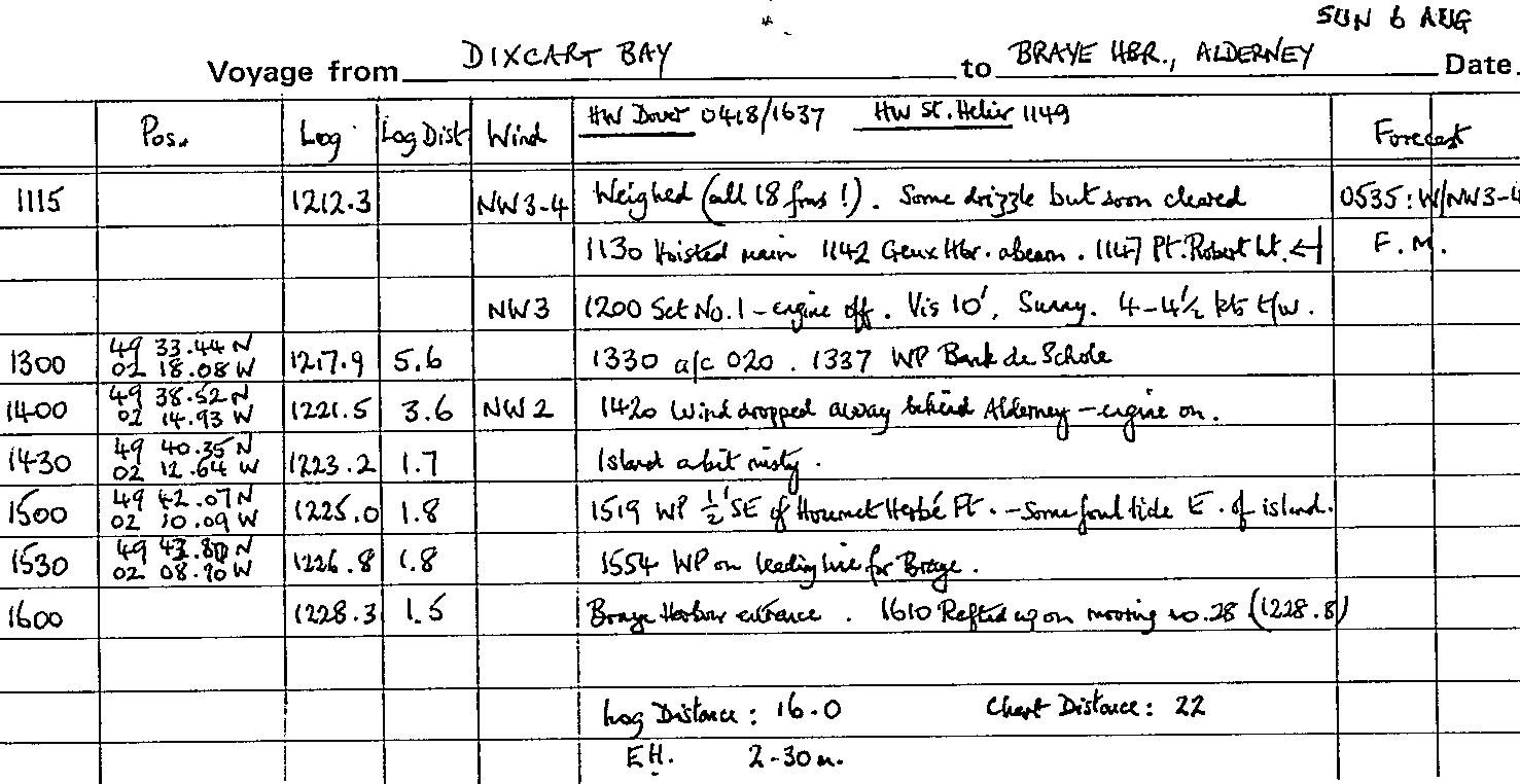
Sunday 6 August arrived with a bright sunrise but it clouded over with a little drizzle, though the forecast fog patches did not materialise. At 1115, after the energetic crew had weighed all 18 fathoms of our chain by hand with surprising ease, we followed a singlehanded Belgian gaff ketch out. Off Point Robert there were signs of overfalls but that was all in the light wind. By 1200 we had cleared the N end of Sark and we were able to cut the engine and take advantage of the NW 3. It was a very pleasant sail over a smooth sea with the sun breaking through and visibility up to 10 miles. With the tide under us we made over 6 miles in the hour to 1400. However, the wind began to drop away, especially as we came under the lee of a rather misty Alderney and by 1420 we were once again under power.
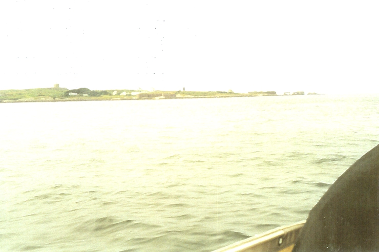
In the conditions we did not have to worry about those alarming symbols on the chart marking heavy overfalls over the banks and we followed round the SE coast of the island about a mile off. Squadrons of gannets from their colony on Les Étacs overflew us as we edged in round the E end of the island, meeting a little foul tide. By 1600 we had made the Braye harbour entrance and were soon rafted up on 'Aeolus', an RNSA Bavaria 34; the harbour was certainly not as full as we had expected. We made a quick excursion ashore for ablutions and a drink. On our return 'Aeolus' departed but at 2100 was replaced alongside us by a Beneteau 38 full of young French trainees from St Malo, together with an American girl as interpreter!
Log entries for voyage from Dixcart Bay, Sark to Braye Harbour, Alderney on Sun 06 August
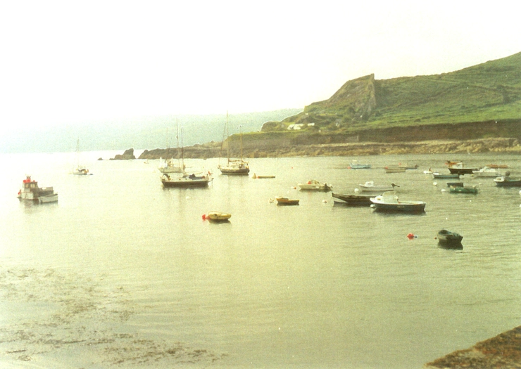
Alderney
Venturing ashore on the Monday morning we found it was 'Cavalcade Day', a bank holiday, so we had a quick scramble for stores before the shops shut at 1100. James and Hannah then hired bikes and spent the rest of the day touring the island; they had a swim at Saye Bay but failed to find a way to Telegraph Bay, a beach which James remembered from visits in his younger days. It was a beautiful, hot and sunny afternoon but by evening a thick mist was rolling in.
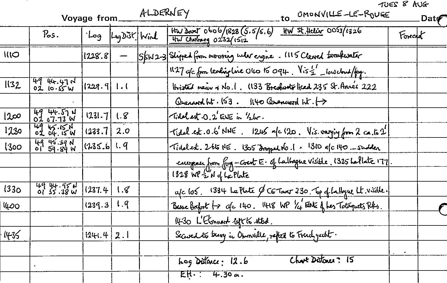
Alderney - Omonville-la-Rogue
High pressure was well established which meant light winds and fog patches and Tuesday morning brought decision time again with visibility between ½ and 1 mile. We decided to go and motored out of Braye at 1110. Quenard Point lighthouse soon disappeared into the murk. We were on the flood tide and by 1230 were steering 120° to counteract the increasing NE set. Visibility varied from two miles to two cables and when it was at its thickest James was posted on the bow to listen out for any approaching engines while flares and lifejackets were laid to hand; our mouth-operated fog horn gave an encouraging volume of sound. At 1310 we came round further to 140° and suddenly emerged from the fog with the coast E of La Hague plainly visible some 2 miles away on the starboard bow. A strange sight was to see the top of Cap La Hague lighthouse, 144 feet high, with its lower half still shrouded in fog, appearing like some disembodied object.
All the while we had been making 6 knots over the ground with the E-going tide now well into its stride. For old time's sake we had decided to spend one night in Omonville-la-Rogue before continuing on to Cherbourg and by 1400 we had the Basse Bréfort buoy close abeam; from there, as the sun broke through, we ran in, skirting Les Tataquets rocks to round Le Tunard beacon and enter the small harbour protected by its breakwater. The large round mooring buoys we had used on previous visits had been replaced by smaller buoys further out and on one of these we rafted up on a smaller French yacht.
Log entries for voyage from Braye Harbour, Alderney to Omonville-la-Rogue on Tue 08 August
Omonville-la-Rogue
Ashore in the inflatable we set out for the small village shop a mile away which we remembered, but halfway we were directed to a new (to us) camp shop where we found the stores we needed - with the last of our French currency.
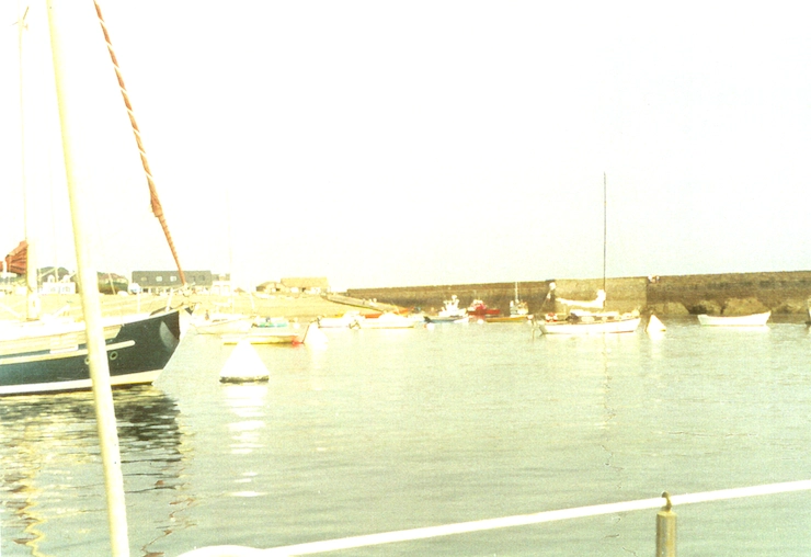
We enjoyed lovely evening sunshine but at 1800 fog rolled in until we could only just see the breakwater less than a cable away. Our night was not as restful as we had expected as a persistent swell had us rolling and from time to time bumping against our next door neighbour.
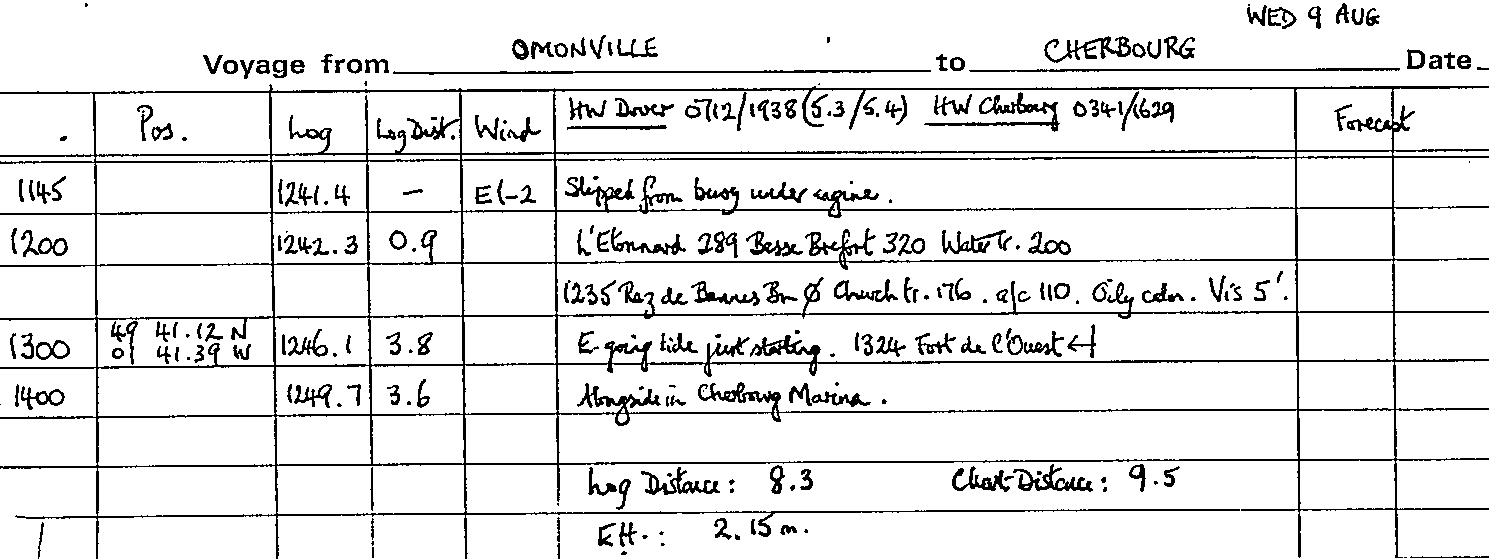
Omonville-la-Rogue - Cherbourg
We had a leisurely morning while waiting for the tide to turn in our favour. The fog had cleared overnight and given way to pleasant sunny intervals. James and Hannah went for a walk ashore and on return Hannah took herself to the forecabin for some clarinet practice - the notes of a Brahms' concerto stealing across the water. Once again there was virtually no wind and it was yet another motor-sail - on an oily calm, with visibility about 5 miles. We slipped from the buoy at 1145 and by 1325 we had covered the 7½ miles to the Fort de l'Ouest - too late, a W 3-4 had by-now set in! At 1400 we berthed in the marina at Cherbourg where there was plenty of space. We spent the afternoon replenishing our diesel supplies and buying stores and 'goodies' at the hypermarket ready for our departure back to the UK.
Log entries for voyage from Omonville-la-Rogue to Cherbourg on Wed 09 August
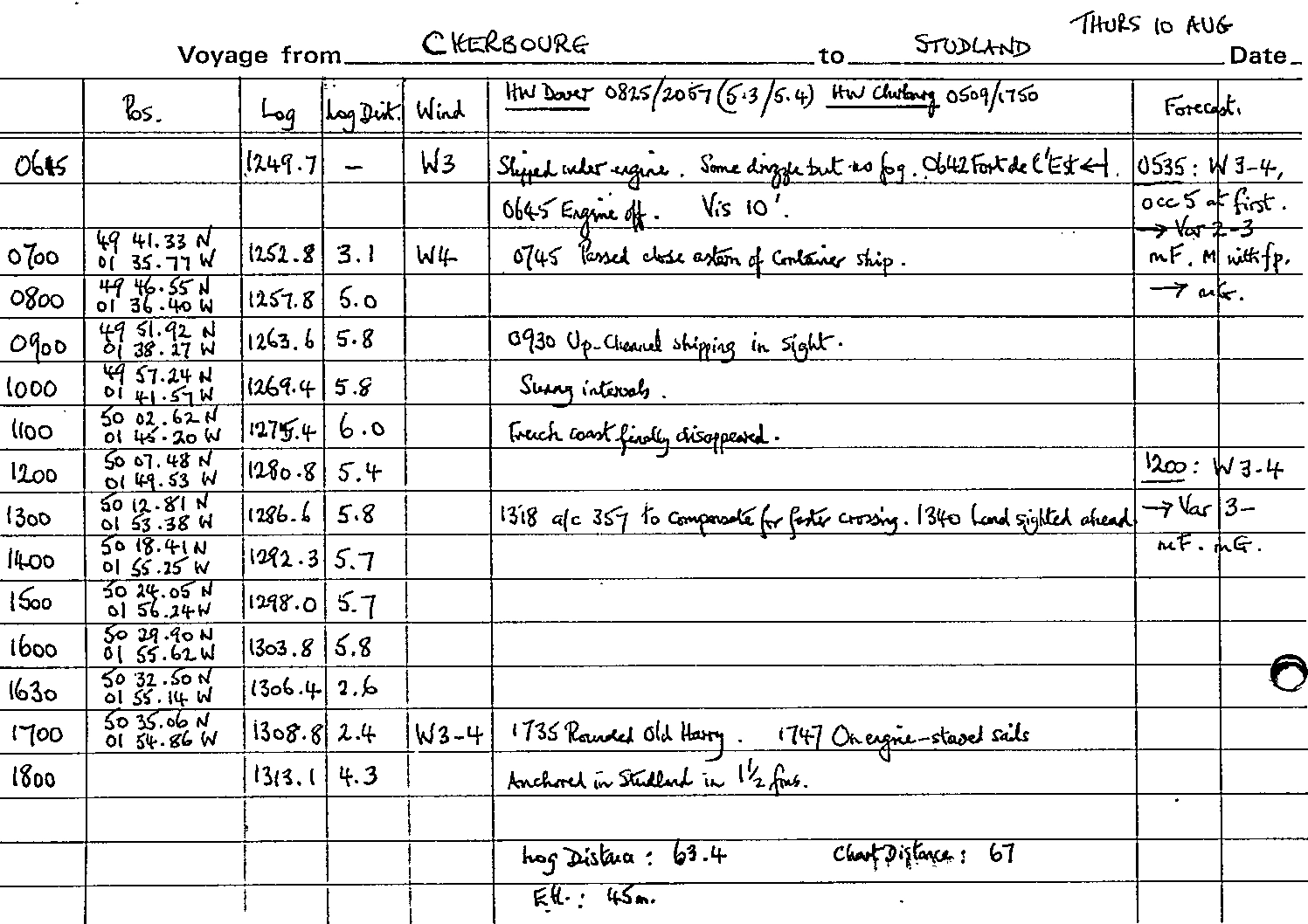
Cherbourg - Studland Bay
The forecast for Friday 11 August still included the threat of fog patches, but in fact the overnight fog had cleared and there was a healthy Force 4 blowing from the west. Many boats were also under way as we slipped at 0615 but most of them were heading west for the Channel Islands now that visibility had improved. On a heading of 352° for Studland we romped along, logging between 5½ and 6 knots hour after hour - a faster speed than we had made our calculations for - and so at 1315 we came round to 357°. Getting one's tidal triangles right on the Channel crossing always includes a bit of guesswork when under sail because of the largely unpredictable boat speed. But it was our best sail of the cruise, ironic when we were heading for home. Snacks came up at frequent intervals - including 'pains au chocolat' and life at sea with a fair amount of sun was very pleasant. We even had to alter course only once - for a ship bound down Channel.
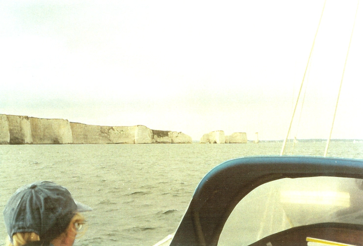
By 1340 the coast of England was in sight. Our navigator was busy checking his tidal streams to allow for less E-going with our ETA now being that much earlier. At 1735 we rounded Old Harry and at 1800 dropped anchor in Studland in 1½ fathoms - just under 12 hours out from Cherbourg Marina (63 miles chart distance), one of our faster passages. We had made for Studland, partly as we had one day in hand, partly because it obviates the need to work one's tide for the Needles Channel.
Log entries for voyage from Cherbourg to Studland Bay on Thu 10 August
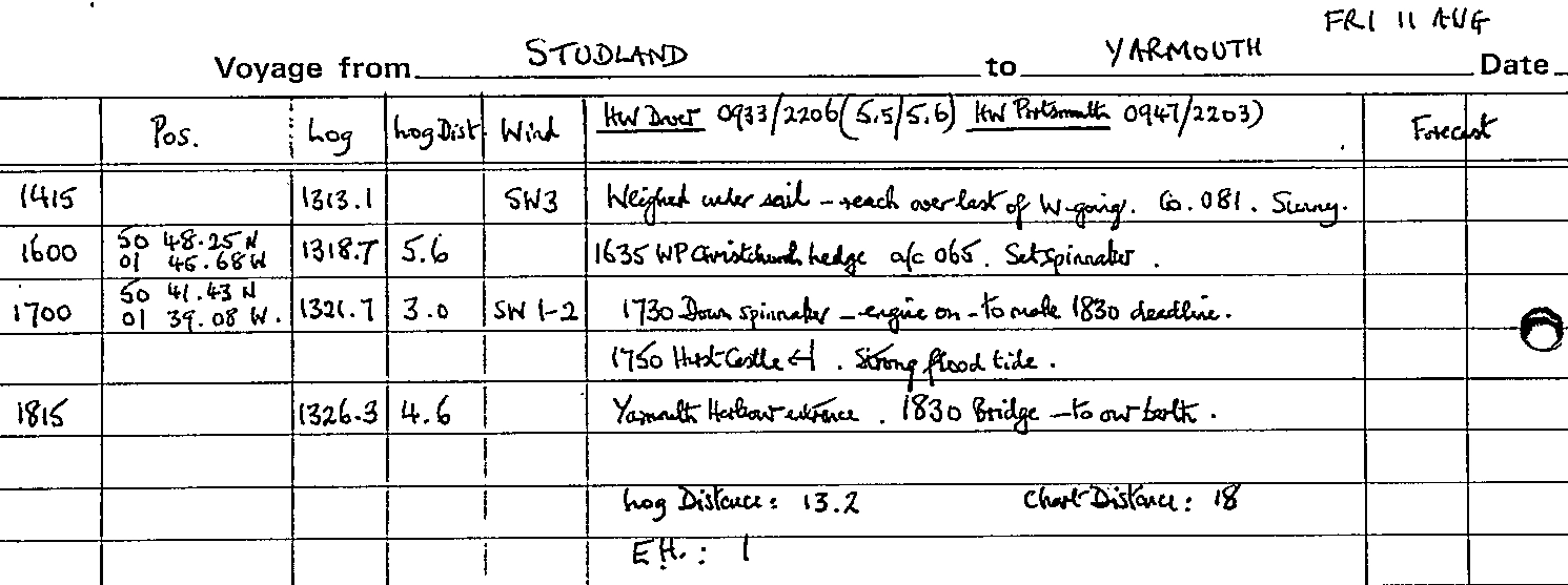
Studland Bay - Yarmouth
Apart from the depth alarm, set at 7', sounding off just after midnight we had a restful night, scarcely disturbed by the Beer Festival ashore - and the oil lamp hoisted on the forestay was still burning in the morning! A sunny Friday morning was spent getting stores ashore at the Studland village shop and on return James and Hannah had a swim. After a leisurely lunch we weighed anchor at 1415 to reach over the last of the W-going in a SW 3. Bright sunshine continued but as we crossed Poole Bay the wind dropped away and even hoisting the spinnaker did not sustain our speed sufficiently to make the 1830 bridge opening. Sadly at 1730 we had recourse to the engine once again as we rounded the North Head buoy. The flood tide swept us in past Hurst Castle and there ahead was Yarmouth Pier and a crowded harbour to receive us. Our last leg was rather an anti-climax, but at least we had had the better breeze with which to cross the Channel the previous day.
Log entries for voyage from Studland Bay to Yarmouth on Fri 11 August
Conclusion
The boat had been away for nearly 9 weeks, but for 3 weeks of that one or more of us had had to be away from her. During actual occupancy we had spent 19 days or part days at sea and 20 days in harbour - 8 of those days held up by fresh or strong SW/W winds when were trying to make westing along the South coast; 3 more days in St Quay and 3 days in St Helier were on account of strong winds.
-
Route: Yarmouth - Poole - Weymouth - Dartmouth - Salcombe - Tréguier - Lézardrieux - La Corderie (Bréhat) - Paimpol - St Quay-Portrieux - St Malo - St Helier - St Peter Port - Dixcart Bay (Sark) - Braye - Omonville - Cherbourg - Studland Bay - Yarmouth
-
Duration: 9 weeks (3 weeks of it in harbour because one or more of the crew had commitments in the UK) - from June to August 2000.
-
Vessel: 'Macaria II' - a Twister built by Uphams in 1965 with glass fibre hull and wooden coachroof; no furling genoa.
-
Crew: Skipper - Brian Mead; his son, James and James's girlfriend, Hannah.